
We will start publishing information on the regulating pond.
To provide easy-to-understand information on river conditions that will lead to swift evacuation for Tokyo residents, the Tokyo Metropolitan Government is publishing rainfall, river water levels, and footage from river monitoring cameras on the Flood Disaster Prevention Integrated Information System and the Tokyo Flood Prevention Channel (YouTube).
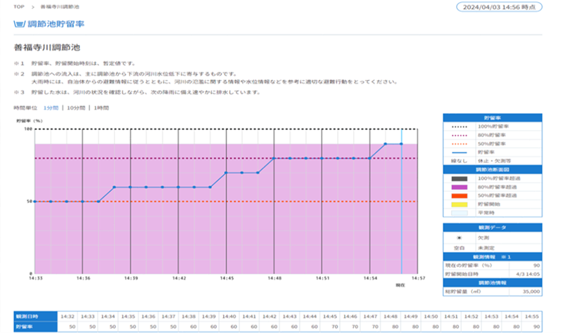
Starting Tuesday, June 4, we will begin publishing information on the storage rates of regulating ponds and footage from intake cameras.
The aim is to enable people to check the inflow status of regulating ponds, which has a significant impact on the safety of the river basin, and to use this information to make decisions about voluntary evacuation, etc.
We will continue to expand the publication of this information in line with the development status of regulating ponds.
1 Adjustment pond open to the public
Storage rate
Furukawa Underground Adjustment Pond and 21 other locations (see attached list (PDF: 170KB))
Water intake camera footage
Irumagawa Diversion Channel and seven other locations (see attached list (PDF: 170KB))
2 Disclosure of reservoir storage rate – Tokyo Metropolitan Government Flood Disaster Prevention Information System


3 Water intake camera footage
Tokyo Flood Control Channel (YouTube) (Link to external site)
*Videos are distributed on YouTube.

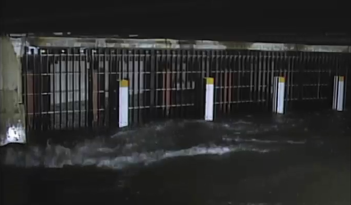
取水口カメラ(妙正寺川取水施設)
This project is a part of the ““Future Tokyo” Strategy“.
Strategy 8: Safe and secure city development strategy
“Promotion of infrastructure development to protect lives and livelihoods from flood damage”
Contact information
Construction Bureau River Department Disaster Prevention Division
Tel: 03-5320-5194
Email: S0000386(at)section.metro.tokyo.jp
*The email address has been changed to prevent spam.
Please replace (at) with @ when using the email address.
その他のお知らせ
-
 Earthquake
 -
 Earthquake
 -
 Wind and flood damage
 -
 Wind and flood damage