Tokyo Metropolitan Government to Start Operation of Landslide Risk Information
Since February 2008, the Tokyo Metropolitan Government and the Japan Meteorological Agency have been issuing landslide warning information after the issuance of a heavy rain warning (landslides) to support the decisions of ward, city, town, and village mayors to issue evacuation orders and residents to decide whether to evacuate on their own when a life-threatening landslide could occur at any time.
We are now pleased to announce that we will begin operating the “Tokyo Landslide Risk Information” as a supplement to the landslide warning information, to support the warning and evacuation systems of wards, cities, towns, and villages by providing the risk of landslides due to heavy rain by district, and to help Tokyo residents evacuate on their own.
1 Start date and time
Friday, May 24, 2024, from 14:00
2 Main features
(1)Provides information on the risk of landslides caused by heavy rain by region
In order to provide Tokyo residents and disaster prevention personnel with easy-to-understand information on areas at high risk of landslides due to heavy rain, the landslide risk level on a 1-kilometer mesh, which was previously provided on the Japan Meteorological Agency’s website in the “Dosha Kikikuru (heavy rain warning (landslide) risk distribution)” section, will be provided by district [Note 1]. In addition, comprehensive monitoring is possible by displaying meteorological information related to landslides, high-resolution precipitation nowcasts and radar rainfall provided by the Japan Meteorological Agency, etc.
[Note 1] The areas where the service is provided are set to reflect the requests of local wards, cities, towns, and villages.
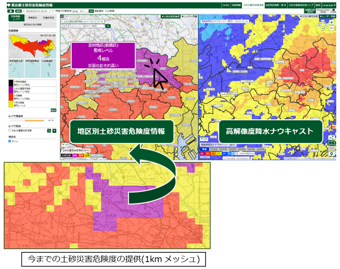
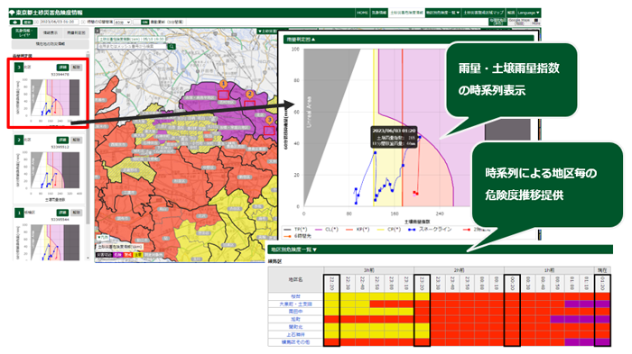
(2)Display of time series information (progression of risk)
By being able to display landslide risk information (time, risk level) by area, you can check the increasing risk of landslides.
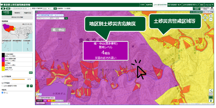
(3)”Landslide hazard areas” and “Landslide risk” are overlaid on map data
Areas at risk of landslides (approximately 16,000 landslide hazard zones in Tokyo) and the landslide risk level are overlaid on the map data, making it possible to see at a glance which areas are at risk when the risk of landslides increases.
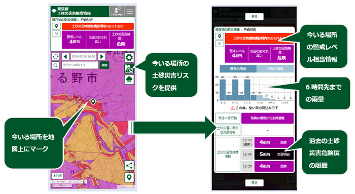
(4)Providing information for smart devices
We will provide a page for smart devices that is easy for Tokyo residents to use. Using the device’s GPS location information [Note 2], you can easily check the landslide warning areas and landslide risk level of your current location.
[Note 2] To use this function, your smart device must be set up to notify the browser of its GPS location.
(5)Multilingualization of the viewing page
It supports four languages: Japanese, English, Chinese (simplified and traditional characters), and Korean.
3 Tokyo Landslide Risk Information Website
Tokyo Landslide Risk Information
(For PCs and smart devices)

4 Related Links
※About landslide disaster prevention projects in Tokyo (Construction Bureau website)
※For an overview of landslide warning information and the system of announcement standards, please also refer to the following.
Landslide Warning Information – Dosha Kikikuru (Danger distribution of heavy rain warnings (landslides)) (Japan Meteorological Agency website) (Link to external site)
※For an overview of high-resolution nowcasting, please also see the following:
High-resolution nowcasting (Japan Meteorological Agency website) (Link to external site)
Contact information
Planning Division, River Department, Bureau of Construction
Tel: 03-5320-5429
Email: S0000383(at)section.metro.tokyo.jp
*The email address has been changed to prevent spam.
Please replace (at) with @ when using the email address.
その他のお知らせ
-
 Wind and flood damage
 -
 Wind and flood damage
 -
 Earthquake
 -
 Earthquake

