
Regarding the designation of the Zenpukuji River as a flood forecasting river.
The Tokyo Metropolitan Government and the Japan Meteorological Agency have designated the Zenpukuji River as a flood forecasting river [Note 1], following the Kanda River, Shibakawa/Shinshibakawa River, Meguro River, Shibuya River/Furukawa River, Nogawa/Sengawa River, Myoshoji River, and Shakujii River.
Previously, the Tokyo Metropolitan Government had independently issued flood risk information [Note 2] for the Zenpukuji River, designating it as a river for water level notification, to be used in making decisions regarding voluntary evacuation during floods. Now, however, it has been redesignated as a river for flood forecasting, and from now on, the Tokyo Metropolitan Government and the Japan Meteorological Agency will jointly issue flood risk information.
[Note 1] What is a flood forecasting river?
This designation is stipulated in Article 11 of the Flood Control Act, and is made when there is a risk of significant damage from flooding. When a flood is deemed likely, the Tokyo Metropolitan Government and the Japan Meteorological Agency jointly inform the public of the situation.
[Note 2] What is flood risk information?
This is disaster prevention information issued when there is a risk of rivers overflowing due to heavy rain, and it is equivalent to alert level 4 information, requiring evacuation from dangerous areas.
1 Operation start date and time
Tuesday, March 17, 2026, 1:00 PM
2 Announcement timing
Based on the Japan Meteorological Agency’s rainfall forecast up to one hour in advance, the Tokyo Metropolitan Government predicts fluctuations in water levels, and if there is a risk of rivers overflowing, the Tokyo Metropolitan Government and the Japan Meteorological Agency jointly issue a “flood risk warning.”
3 Information dissemination to Tokyo residents
Your local ward or city will transmit information via disaster prevention radio and email services, and will also work with media outlets to raise awareness through television and radio. You can also check the flood risk information currently being issued on the Tokyo Metropolitan Government and Japan Meteorological Agency websites, as well as on Tokyo Disaster Prevention X.


4 When a flood warning is issued
Because the water level of the Zenpukuji River rises extremely rapidly during heavy rains, there is a risk of the river overflowing shortly after a flood warning is issued.
If a flood warning is issued, please take prompt action in dangerous areas along rivers, such as moving out of basements or other places at high risk of flooding, or evacuating to higher floors of buildings.
(Reference) Map showing the location of the Zenpukuji River
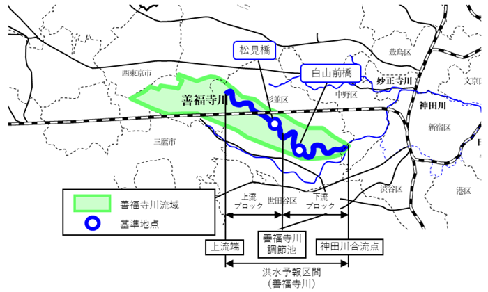
*See attached document for reference (PDF: 450KB)
This project is an initiative to promote the “Tokyo 2050 Strategy.”
Strategy 21:Strengthening urban resilience: “Strengthening measures against increasingly frequent and severe wind and flood disasters”

| Contact: Construction Bureau, River Department, Disaster Prevention Division Phone: 03-5320-5190 Email: S0000386(at)section.metro.tokyo.jp *The email address has been changed to prevent spam. Please replace (at) with @ when using this email address. |
その他のお知らせ
-
 Earthquake
 -
 Earthquake
 -
 Earthquake
 -
 Wind and flood damage